Go back


Maps
Maps in the collections of the Dennys River Historical Society.
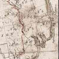
Dennys River, Lottery Map detail, 1786
Map
Google Earth view of the Dennys River
Map
Lottery Map 1784
Map
Map and Plan of Machias, Maine, c. 1875
Archive
Map: Charlotte-Putnam-Pre Civil War Draft
Map
Map: Dennysville c. 1825
Map
Map: Eastern Portion of Edmunds 1839
Map
Map: Edmunds 1836-B.R Jones
Map
Map: Edmunds c. 1820
Map
Map: Plan of Dennysville, Pembroke, Perry, and Charlotte
Map
Map: Rough Draft of Edmunds, 1820
Map
Map: Township 1, c. 1800
Work on Paper
Map: Township 2, 1800
Map